Adventures
Day 21: Foul Occurrences
|
Salida, CO (4 July 2019)Late in the day, a past mistake started to make an impact. As a result, I was balanced precariously above a reservoir inlet, in an attempt to filter water. A sudden loss of balance caused the entire water filter to be fumbled into the algae covered water. After the filter was rescued from the drink, a bit of clean water was used to rise off the clean water exit port. Despite the contamination, the filter was used to gain a liter of water for the next day of riding. That liter was not nearly enough but I was hesitant to filter more using the suspect water filter.
Much earlier, Mikki and I set off from Salida for supplies in Poncha Springs. The morning was cool and sky promised sunshine ahead. It took two days to get from Salida to Del Norte with only two stops for supplies. The first was in the town of Poncha Springs, which was 7 miles from Salida and the second was an outpost in unincorporated Sargents, 44 miles from Salida. After Sargents it was another 115 miles to Del Norte, which made attention to food and water supplies essential. Water was particularly important because the days were hot and the landscape was parched.
Poncha Springs is a small town with plenty of services. Mikki and I stopped at the Poncha Market and it was awesome. The deli made sandwiches to order and the people were very friendly. A second breakfast to eat onsite, dinner for later and lunch for tomorrow were purchased for the ride ahead. It wasn't easy to carry it all but I knew from experience that the offerings in Sargents would be more limited.

|
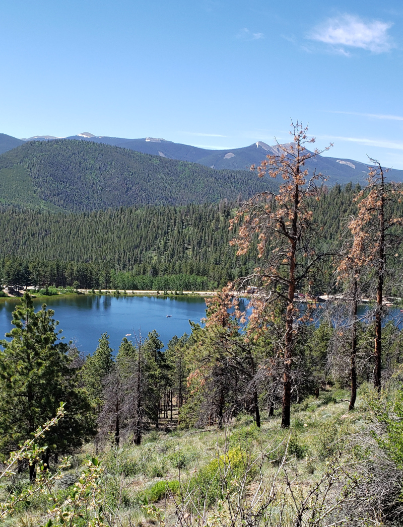
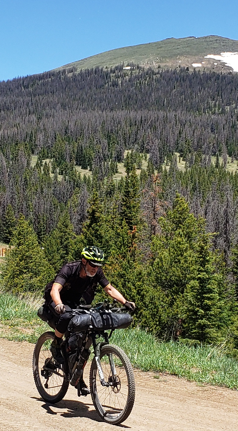
The start of the climb to Poncha Pass enveloped me in memories of past rides with my wife Pat and good friends. Poncha Pass was particularly memorable. In 2002, for example, the Ride the Rockies route took us over Poncha Pass from Poncha Springs to Alamosa. Our group on that tour included my wife Pat and friends, Adam, Dan, David, Evan and Jack. This was the ninth year in a row Jack and I participated in a week long tour in Colorado and not the first time we topped Poncha Pass. Those memories powered my legs as I pedaled up Poncha Pass with Mikki close behind. Before the top of pass, the Tour Divide turned off the highway onto a gravel road, where an entirely new set of memories were made.
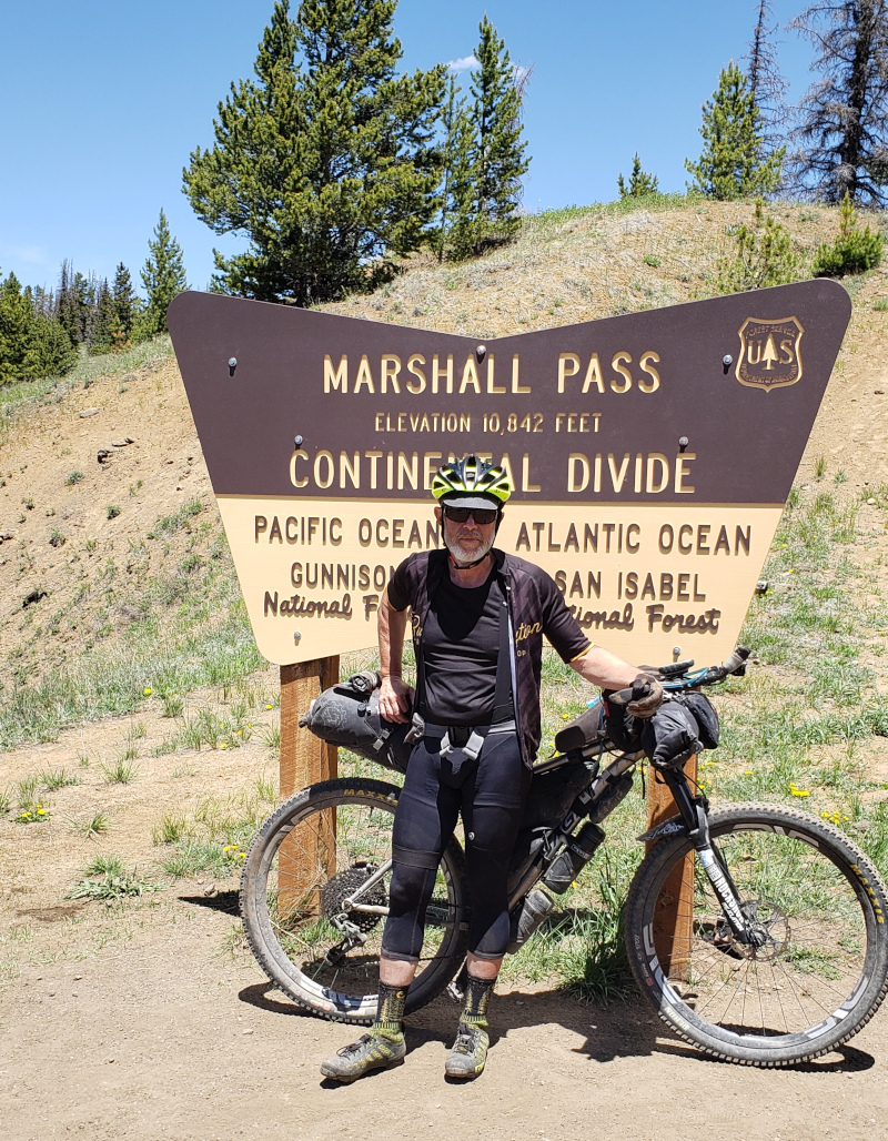
The climb to the top of Marshall Pass started the moment the route turned away from the highway. The gravel road started with a few tight switchbacks but soon settled into a consistent gentle grade. This was another route once used by a railroad. The views from the gravel path up the pass were incredible. For me, at least, Marshall Pass was so pleasant and so scenic that it won my award for the most enjoyable climb on the Tour Divide. Most enjoyable but not my favorite, that was still ahead.

|
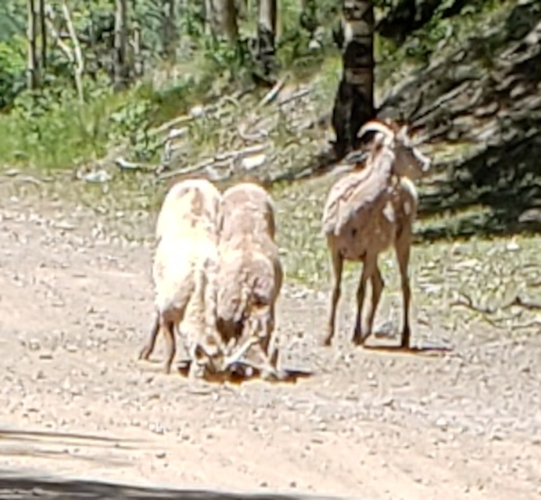
Mikki and I rode side by side. Ahead I noticed a flash of yellow which could only be another cyclist. The yellow dot flashed past a few smaller gray dots on the gravel ahead. As we got close, the gray dots resolved into three molting Big Horn Sheep. I guessed by the horns on the trio that these were females or juveniles. Mikki and I stopped to watch as the sheep pushed their noses deep into a hole in the gravel path. It appeared they were after the dissolved minerals in what water they could draw from the hole.
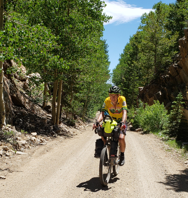
The yellow clad cyclist was Jim Raddatz. We joined him not long after we stopped to watch the sheep. The easy going path began to twist as rock walls rose high on one side. The stream on the other side rushed quickly among the trees and rock. Further on, the path gradient increased as it left the stream and the trees behind, which gave the sun a chance to burn off what little coolness remained from the morning.
|
A group of young people on ATVs were stopped at a switchback on the climb. This road was not traveled by cars or trucks but several ATVs were seen. My experience on shared paths in Colorado has been uniformly good. Once near Crested Butte, we were on bikes riding up a steep climb on a trail called Deadmans when three motorcycles were seen heading in the opposite direction. When they saw us, the motorcyclists paused, turned off their engines and picked their way carefully down the hill past the three of us. That was by no means the only time I was impressed by the shared use ethic on the trails in Colorado. It occurred to me that the group of young people stopped at the switchback may well have done so to wait for us to pass. In any case, these experiences have convinced me that shared use paths can work, provided the people that use them remain respectful of one another.
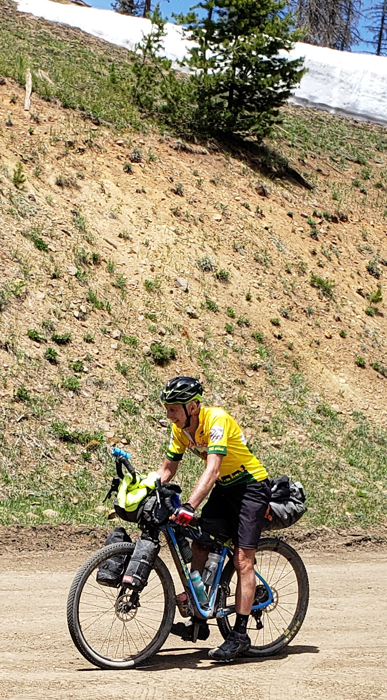
Just prior to the very top of pass, a great place was spotted for lunch and taking in the view. Perched on a rock, a nearby hole was noticed that might have been home to a rattlesnake. The snow above the road was deep and I watched two young kids as they left an ATV to climb up to the snow line just to touch it. The dry road was clear of snow and the sun was quickly warming the day. The view from the rock was wide and included the switchback where the ATV riders were still waiting, perhaps for those that could not resist the snow. After eating, pictures were taken of the others as they cycled past.
|
The downside of Marshall Pass was fun but like most descents on the Tour Divide, it was rough. At one point Mikki and I were headed down at a good clip when my rear wheel suddenly locked up. The bike was controlled as it skidded to an abrupt stop. A big bump in road caused the Ortlieb seatbag to bounce down onto the rear tire which grabbed it and folded the bag under the saddle. With the bag jammed against the tire, the wheel would not turn. It was frightening but no harm was done and the wheel was released easily when turned in reverse. Controlled skids are fun when purposeful but unnerving when unexpected.
There's almost nothing in Sargents, Colorado. Although what is there, the Tomichi Creek Trading Post, has everything. A store, camping, lodging and a restaurant all stand on the trading post grounds. I remembered this place as the start of the climb to Monarch Pass which is, perhaps, the most satisfying pass in Colorado for a road cyclist. It's not the hardest or the longest or the highest. But it's hard, long and high. It is very satisfying, in my book, because it is consistent. The grade is consistent and the valley behind is large which creates a consistent tailwind that pushes road cyclists up the pass. Once we spent two hours hanging out at the trading post before the climb to Monarch Pass. The delay was caused by a fire which started in a camper parked on the side for the road. I was looking forward to a much shorter visit with Jim and Mikki on the Tour Divide.
|
|
It felt strange, after weeks of bikepacking all sense of the calendar was lost. When we entered the Tomichi Creek Trading Post, I was surprised to learn it was the fourth of July. It turned out this was important because on the fourth, the restaurant menu was limited. There were three lunch options. All three were full meals but all were for meat eaters. Fortunately for me, turkey was on my list of exceptions to my mostly vegetarian diet. Along with some sides, the restaurant served an entire turkey leg. It was no challenge for me or any cyclist who spent the morning climbing Marshall Pass.
|

|
The three of us enjoyed our lunch together and brought supplies for the 115 mile trek to Del Norte. Even water was not entirely certain on the road to Del Norte, although there were a couple of campgrounds and a reservoir along the route. Still it was always better to have more than enough water when biking through a parched landscape. I filled water bottles and a 3 liter bladder, the weight of which was added to the backpack. This was only the second time the bladder was used, in part because of the weight it added to the saddle.
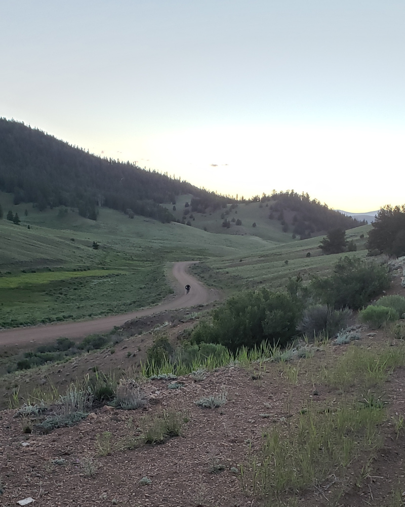
After the stop in Sargets and a bit of pavement, we returned to some gorgeous gravel roads. Jim biked ahead as Mikki and I continued to roll along bar to bar. I enjoyed the open rolling terrain of grass and sage. There was a breeze and the sun baked us as we pedaled along.
The water tasted funny. When water was sucked from the bladder through the attached hose, it tasted strange. Vaguely odd at first but as time passed, a chemical taste became apparent. Back in Silverthorne, the bottle of insect repellent purchased at the Flagg Ranch in Wyoming was discarded. Despite being closed in a Ziploc bag, the bottle leaked and covered the items in the backpack with repellent, the bladder included. The backpack was washed and cleaned as were the items in the bag. As Mikki and I pedaled along, the chemical taste continued to increase until finally it became too much to take. The bladder was dumped out at a stop. The water in bladder was too foul to drink. Bottles would have to be filled at either the reservoir or the campground ahead.

|
The banks of the reservoir were high -- plus I spaced out. Mikki and I investigated a pull-off with a toliet block but I made no attempt to get to the water there. When we got to the inlet, it suddenly occurred to me that water was needed. Water at the campground could not be relied upon. To add to the water problem, my water filter became contaminated when it was accidentally dropped into the reservoir. In the moment, I did not know what to do about it. Later at camp, the water filter was disassembled, hand sanitizer was applied to all the parts and it was left out to dry. I felt much better about the filter but didn't feel good about the liter of water filtered before it was cleaned. Even with the questionable water, there wasn't enough water for the next day. The campground lacked a supply of water which seems to be normal for this part of Colorado. Fortunately, Jim obtained some excess from a friendly camper prior to our arrival. Even with the two bottles of water from Jim, my supplies were less than desirable for the 64 miles remaining to Del Norte.
The campground was near the top of Cochetopa Pass which was over 10,000 feet. It seemed like a short climb to the pass and we both cycled at a relaxed pace. It seemed short because it was a very long, gradual climb which tipped upward more steeply toward the end. Despite the elevation, the evening air was pleasant as it wafted through my tent. The tent was placed on the edge of a forest overlooking a high meadow of short grass. Under a dark sky, I laid in the tent and imagined deer grazed just outside. An eye was cracked but no animals were seen and sleep came swiftly.
|
It was a good, enjoyable day that left me in a precarious state. Marshall Pass was spectacular. It turned out buying dinner at 8 AM in the morning was genius. Otherwise dinner would have been made from what could be scrounged from the Tomichi Creek convenience store. My water bladder was fouled by insect repellent and was useless when I planned to rely on it. Adding to the problem, the water filter was fouled by clumsiness when it was dropped into the reservoir. My lunch was just, well, fowl but that I enjoyed. Tomorrow would tell if my water supplies were sufficient for a 64 mile bike ride across a parched landscape.
|
Things to know
The Route
Ride With GPS Tour Divide Route (copy) Be aware that the Tour Divide Race route differs from the Adventure Cycling Great Divide Route in several places. I don't know what the differences are because I only researched the Tour Divide Routes.
Food
Tomichi Creek Trading Post in Sargents
Camping
Summary
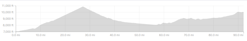
Day 21 Salida to Cochetopa Pass, 92 miles, 6,802 ft climbing, 14:05 hours (9:50 moving)