Adventures
Day 20: Positively Salida
|
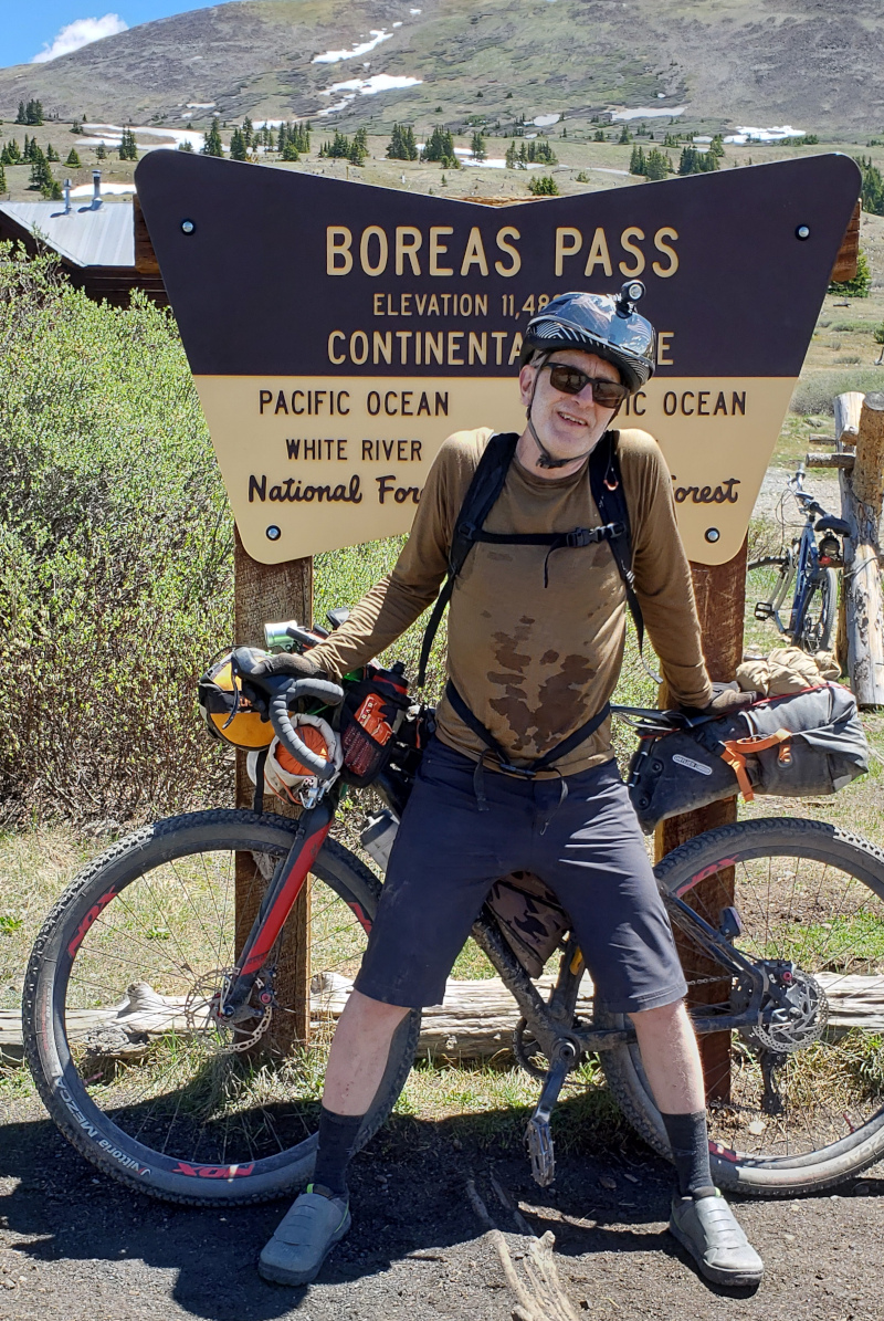
Silverthorne, CO (3 July 2019)Norma lifted her bike over her head while her boyfriend took the picture that marked her accomplishment of riding to the top of Boreas Pass. Norma, her friend and several others gave me a much needed lift on a day that started badly.
The route snaked through Silverthorne on a bike path until the GPS unit indicated the route turned onto a road. It was a short trek up a grassy hill to reach the busy highway. The motorists were not happy when they saw me, as I biked slowly up a rise on the roadway. Several honked horns and one or two shouted something that could not be understood. Finally, a young man on a moped came alongside and told me there was a bike path that runs parallel, along the opposite side of the highway. At an appropriate place, I stopped, crossed and lifted my bike over a rock wall to reach the previously hidden bike path. It felt terrible to be caught so unaware. Back home, I often wondered how difficult it was to navigate Madison for cyclists that are not familiar with the area. Clearly, it was annoying and unsafe, not unlike what I just experienced.
|
In an attempt to adjust my attitude, a stop at a Frisco coffee shop was made. The place was busy with locals and tourists. A second breakfast consisting of a burrito and some fruit was consumed as I tried to relax and get out of a funk. Anxiousness crept in, however, as the clock ticked away the day. No point in sipping coffee when it only made me anxious. It felt better to be back on the bike path headed out of Frisco toward Breckenridge, the last of three adjacent communities navigated that morning.
Less than a mile after I left the coffee shop, it happened again. The route appeared to head cross-country from the bike path to the highway. The bike path was followed a bit further just to be sure but no clarity was gained. Back where the route appeared to diverge from the bike path, I examined the options. It was decided to stick with the path and trust that it was close enough to the route. After getting harassed on the highway earlier, the highway was to be avoided. Jim Raddatz appeared and he was similarly confused. I told him the bike path was my chosen route. He did not seem convinced when I pedaled off.
Breckenridge was busy, as the route sliced through the center of town by a route that was familiar to me. It was a congested city street and lacked the urgency of the highway. The slow speed and frequent stops made for a more harmonious ride among the motorists. Special attention to pedestrian traffic was required, however. Impatience crept in but caution was not diminished.
Engulfed by frustration, I plodded slowly up a hill and away from Breckenridge. In that moment, everything was wrong. The difficulties of the past morning was a weight on my shoulders. The route betrayed me, the convenience store lacked supplies and motorists scolded me with horn and voice. Hours were lost as the adjacent communities of Silverthorne, Frisco and Breckenridge were navigated. I was miserable.
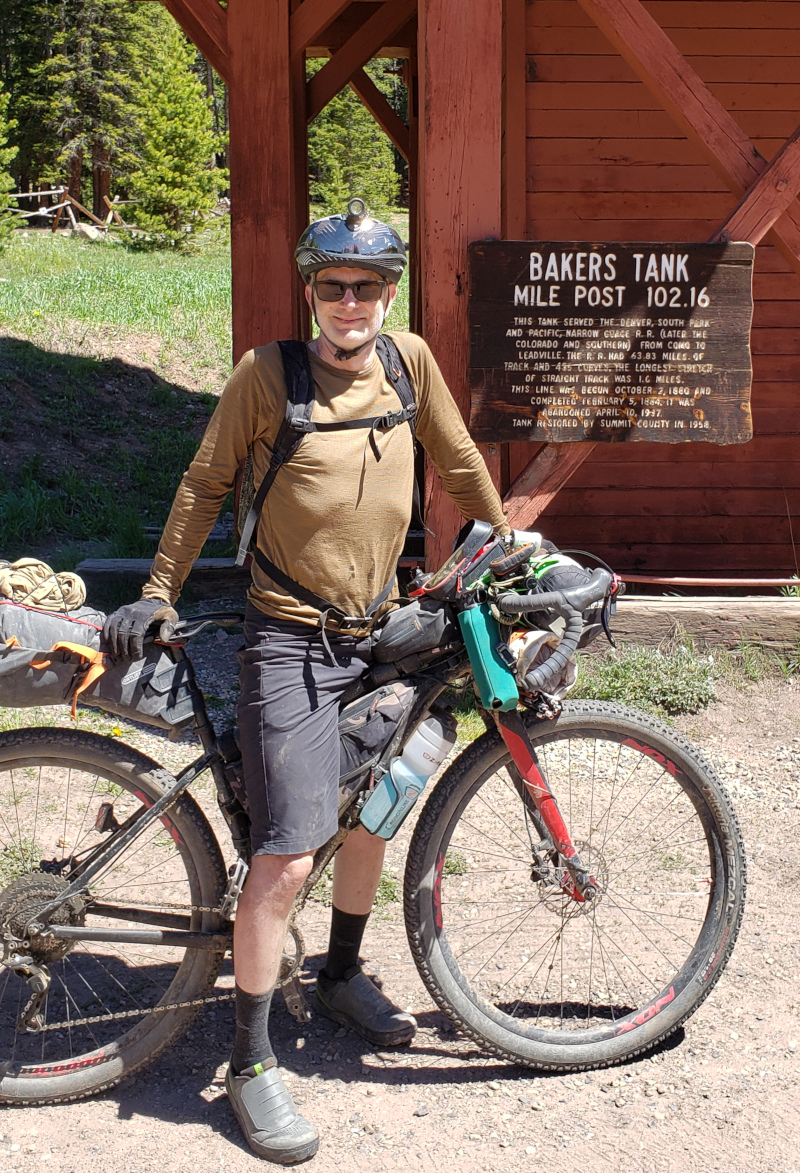
Suddenly, an athletic woman on a mountain bike came alongside, as I plodded up a hill. She cheerfully asked how it was going, to which I replied, "Okay, I guess," in a voice that channeled Eeyore from Winnie the Pooh. She immediately recognized my need for a lift and described, in an expectant tone, what was just ahead. The paved road we were on led to a crushed stone path which gradually ascended to Boreas Pass. The path was the remains of a rail line which ran from Denver to Leadville. I felt energy return and finally noticed that the day was bright, the air was fresh and the coolness of the morning was just starting to fade.
The young woman thought the Tour Divide was an amazing challenge and was happy she came upon me. Soon she powered ahead to ride some nearby single track. Her visit left me transformed. In an instant, my focus went from problems past to the beautiful day as it unfolded in front of me.
|
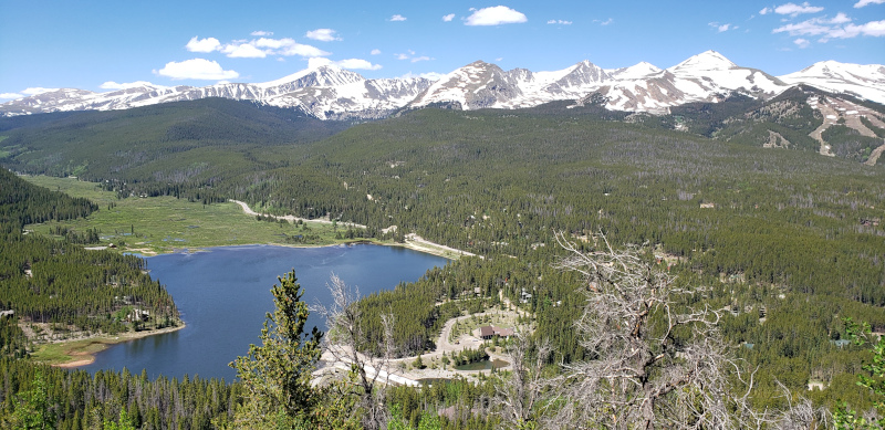
It felt like a vacation, the view was gorgeous and lots of people enjoyed the wide gravel path to Boreas Pass. It was a good climb from Breckenridge at 8,700 feet to the pass at 11,481 feet in elevation. It was beautiful and not difficult, as it followed an abandoned railroad grade. Normally, I felt the altitude more acutely above 10,000 feet. After nearly three weeks on the Tour Divide, the elevation was less noticeable. There was no escaping the effects, however, which made it important to avoid long drinks of water and not press too hard on the pedals. During my first Ride the Rockies tour, a long drink from the water bottle caused dizziness so strong that the incident still came to mind whenever 10,000 feet was surpassed.
A young man was found to be walking his mountain bike back toward Breckenridge. He had a flat which he was not interested in fixing. Using my tire pump and with some instruction, he inflated the tire and hopped on his bike. His spirits were high and he was certain that was sufficient to get him home.
After topping the pass and taking a photo, I met Norma and her friend. All three of us were very happy for her accomplishment because she had been planning this for some time. It was infectious being near two people that were overflowing with joy. They were excited we met and seemed to hold a certain reverence for everyone who attempted the Tour Divide. It was a fresh, energizing boost to a day that started badly. Of course, the actual circumstances were not horrible, it was my attitude that was dragging me down. The instantaneous transformation that resulted from meeting and talking with the people on Boreas Pass was proof of that.

|
The Gold Rush Trail was primitive single track that dropped off the mountain toward South Park. Parts of the trail were fun. Limited view of the trail, as it twisted through trees and tight places, made parts of the trail slower and less fun. There was debris on the trail and an off-camber bridge over a fast moving stream where I barely managed to stay upright. Later I learned that Hall Russel had a slight mishap on that bridge.
The single track was interrupted briefly by a road. When the road was reached, Randy Rice was standing there. He asked me if I saw his son, Billy. At the time I did not know that his son was famous for doing the Tour Divide for at least two reasons. First, Billy Rice completed the Tour Divide Yo-Yo, where the route was followed one end to the other and back again. He also did the Tour Divide route on a tandem with his 16 year old daughter. Randy hoped Billy would return and was not entirely sure which segment of the trail he was on. As it turned out, Billy was walking the trail in search of something Hal Russel dropped. When I asked about Mikki, Randy indicated he was about an hour ahead. As a result, my mind created numerous mirages of Mikki from distant objects near the road, during the many hours spent crossing the wide flat basin.
South Park is a south-plunging basin of grassland located in the geographic center of Colorado. The basin contains a few glacial drumlins and other drift, mostly along the edges. Erosion also created a few hills but the landscape was overwhelming flat. The Tour Divide route used only 4 miles of highway 24 in South Park. Despite this, when that section was completed, I felt the most dangerous part of the entire Tour Divide was behind me. Past trauma notwithstanding, those 4 miles were thankfully uneventful.

|
More than thirty miles after Randy was left standing on a remote road north of South Park, he appeared again! The bike rolled easily away from South Park on a gravel road, as the sun was low and the shadows were long. Randy pulled up alongside in a pickup truck and Billy leaned out of the window while we exchanged a few words. From him I learned, after the next rise the road dropped into a valley where frost has recently occurred. Between that valley and Salida was a climb of over 1,000 feet. I was not inclined to push over the climb today but Billy's encouragement made me consider it.
It was getting dark when the climb near Cameron Mountain was fully engaged. The road was rough and washed out in places which made it tricky to retain traction on the climb. The climb was short and steep in places. I felt good on the climb despite over 14 hours on the road that day. It was dark when the top of pass was reached. There was a glow in the west and the most beautiful silhouette of peaks in the distance. It felt magical and then the road tipped downward. It was all downhill from there to Salida!
The road was steep and the bike dropped down the mountain like a stone. It was thrilling. The lights on the bike and helmet illuminated the road ahead while it was pitch black outside of this cone of light. When the helmet light was turned to the left, nothing was illuminated which indicated a scary drop-off. My speed was kept under control and the extent of the drop-off was happily kept a mystery. Fortunately, the gravel road was smooth which increased the joy of the descent tremendously.
The Woodland Motel was fully booked when I arrived. My phone was used to search for alternatives but before the screen came into focus, Mikki rolled up to save me. It was a happy reunion and he kindly offered to share his room for the night. Mikki enjoyed my story of seeing the mirage of him during the long crossing of the South Park basin. It was from Mikki I learned who Randy and Billy Rice were because I had no idea at the time.

|
It felt good to be in Salida after nearly 15 hours and 116 miles on the road. Salida was special to me. It was where ashes of my dear friend Jack were spread. Along with other friends, Jack and I enjoyed many weeks riding bikes in Colorado on Ride the Rockies and other tours -- most of which included an overnight in Salida. For this reason, Salida was loaded with memories. I felt a sense of reverence for Jack and the experiences we shared. Jack always made easy conversation with people during these tours which enriched our ride. Perhaps it was Jack's example that caused me to stop to help fix a flat and introduce myself to Norma and Randy. In any case, everything changed for me as a result. In the morning I was heavy with frustration but in the afternoon and on into the night, I was joyously light. The essential difference was the gift of a positive attitude gained from the people encountered along the way.
|
Things to know
The Route
Ride With GPS Tour Divide Route (copy) Be aware that the Tour Divide Race route differs from the Adventure Cycling Great Divide Route in several places. I don't know what the differences are because I only researched the Tour Divide Routes.
Food
Lots of places for food in Salida (visited none)
Lodging
Woodland Hotel, (719) 539-4980
Additional lodging options on hwy 50
Summary
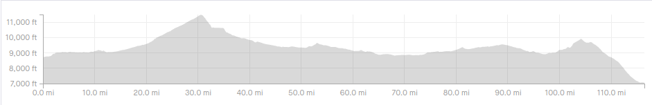
Day 20 Silverthorne to Salida, 116 miles, 6,207 ft climbing, 14:45 hours (11:40 moving)